News
Bridesdale Farm
Posted 26 06 2017 by Megan Harshey
in News
Queenstown's First SHA
“Housing Crisis”; it’s the hot topic on everyone’s lips at the moment, regardless of where you live. Queenstown in particular has come under pressure in the last couple of years to provide for the increasing demand for affordable housing.
In 2014 a Government housing accord was signed with the goal to increase the housing supply in Queenstown by 1,300 properties in three years. In 2015 fourteen developments in Queenstown applied for SHA status (Special Housing Area). Bridesdale Farm was the first development in Queenstown to be earmarked as a Government fast tracked SHA.
SHA is designed to fast track plan changes, bypass costly and lengthy consent requirements and alleviate housing pressure for the country. Although the process didn’t end up occurring as fast as thought, a couple of weeks ago titles were released for Bridesdale Farm and builders were eager to get on site to start construction.
Bridesdale Farm is located between Queenstown and Arrowtown, on the eastern edge of the residential development, Lake Hayes Estate. It is located within rural farmland looking out across the Kawarau River and to the Remarkables beyond.
Bridesdale Farm is located across three Planning Zones. These Zones include the Low Density Residential (LDR) Zone, the Rural Residential (RR) Zone and the Rural General Zone. Similarly, Bridesdale Farm straddles two landscape categories within the Rural General Zone, being the Visual Amenity Landscape (VAL) and Outstanding Natural Landscape, Wakatipu Basin (ONL).
The proposal included the subdivision of 4 land parcels into 137 lots, 137 garden allotments, road reserves and open spaces. The existing zoned residential neighbourhoods to the west of Bridesdale Farm, including Lake Hayes Estate and Shotover Country contain, or will contain, approximately 1300 residential sections as well as small commercial precincts and a school (catering for approximately 600 pupils) which opened in February 2015. The Bridesdale Farm proposal is considered a logical extension of this residential pattern
The landscape of the site and surrounds is relatively complex displaying landforms that are typical of the Wakatipu Basin. These landforms include river terraces, roche moutonnée features, escarpments, wetlands and rivers. At the coarse scale, Bridesdale Farm exists where the river valleys and floodplains meet the river terraces. These terraces then ascend to meet the roche moutonnée features and the flatter lands of the Wakatipu Basin.
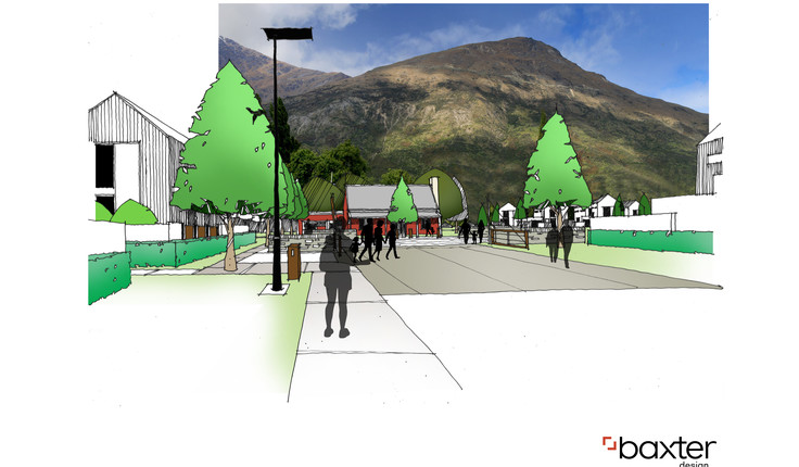
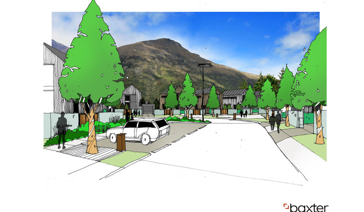
The Bridesdale Farm design took a unique approach to residential development in the District. The design responds to the increasing market demand for affordable housing. The bulk of the proposed lots are sized between 270m2 and 320m2 , a first for the Wakatipu Basin. A comprehensive approach to housing was proposed for about 80 percent of the Bridesdale Farm lots, which set architectural form, size and materiality. Those Bridesdale Farm purchasers had the choice of nine architecturally designed dwellings. Each of the designed dwellings had a predesigned garden. This design consistency set the look and feel of Bridesdale Farm, providing a quality and contiguous street amenity which lead to a ‘village’ character.
A unique component of the Bridesdale Farm proposal was the Bridesdale Farm Garden Allotments. The purchase of a section at Bridesdale Farm included the title to one of these unique garden allotments. These 110m2 blocks of land are located on the lower, southern portion of the development previously old fertile farmland. These allotments will entitle Bridesdale Farm residences to a ancillary block of land to be used for production or horticultural purposes. The garden allotments will be fully landscaped and are designed to become a recreational area, with well-tended private gardens. The rich earth is perfectly suited to contain a large vegetable garden to grow fresh produce.
Community spaces are focused around the existing heritage listed McBride Cottage (the red cottage) and include the children’s playground and market square. The McBride Cottage was the focal point of the design with the northern entry road aligned to the cottage. The retention of the red cottage and mature walnut trees will perpetuate the heritage associations of the area while being a key organising feature of the residential; development.
To the north of the existing cottage will be the Market Square, a quality outdoor space which can be closed to vehicle movement to allow for community markets and other events. The Market Square otherwise remains an integral part of the vehicle network, effectively separating the northern and southern circulation areas by slowing traffic through a coarse paving material. The landscape treatment of the Market Square will give precedence to pedestrian movement as opposed to vehicle movement.
The Bridesdale Farm community is well linked to the popular trails in the vicinity. These include the Lake Hayes Circuit and the Twin River Trail. These trails connect to the wider network of trails which service the Wakatipu Basin and beyond.
While the development proposes a higher density of development in the respective zones and encroaches into the ONL, it is well contained by landscape features and appropriately addresses modification to the more sensitive portions of the site; mainly the terrace face. It is considered that the Bridesdale Farm proposal is a logical extension of the existing landscape’s residential pattern, taking it to the edge of the existing residential landscape unit and appropriately blending the residential development into the more natural and open landscape features.
Bridesdale Farm will enable significant positive effects to occur on the ONL, including:
- The preservation and enhancement of wetlands and marshlands at the base of the terrace.
- An increase in density and diversity of native species across the terrace face.
- The creation of an ecological link between the wetland areas at the base of the terrace and the riparian corridor of Hayes Creek, which in turn links to the Kawarau River and Lake Hayes itself.
- A decrease in the presence of noxious weeds.
- A consistent vegetative cover across the terrace face.
- Allowing public vehicle access to the ONL.
- Increased public access to the nearby Twin Rivers Trail